
The Sainte-Catherine District is one of the easiest places in Brussels to “live like a local” for a few hours: walkable quays, seafood traditions, terrace culture, and a nightlife scene that doesn’t require a plan. The Sainte-Catherine District is especially known for its dense mix of restaurants, bars, and cafés—many of them fish-focused—because this area was historically Brussels’ fish market and port.
This guide shows you what to do, how to navigate the district efficiently, what things cost (including the simplest public-transport ticket options), and the common mistakes that make first visits feel “meh” instead of great.
What is the Sainte-Catherine District? 🗺️
Think of the Sainte-Catherine District as a compact triangle around Place Sainte-Catherine and the old port quays (the “fish market” area). For centuries Brussels’ port reached into the city centre; the district still carries that memory in place and street names and in the seafood-heavy restaurant identity.
Today, the district’s vibe is:
- Food-first (seafood classics + modern bistros + casual bites)
- Terrace culture (especially around the square)
- History in small doses (old quays, a landmark church, medieval fragments nearby)
- Walkable connections to Dansaert, Bourse, and the Grand-Place area
Sainte-Catherine District highlights you shouldn’t miss ✅
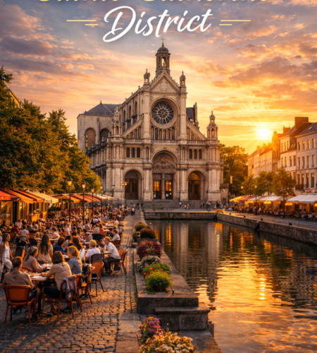
Place Sainte-Catherine (the social “living room”)
Place Sainte-Catherine is a lively square lined with terraces and regularly hosts popular events, often linked to gastronomy.
If you only have time for one stop in the Sainte-Catherine District, make it this: you’ll instantly understand the neighbourhood’s rhythm.
Église Sainte-Catherine + the nearby “layers” of old Brussels ⛪
Right on the square sits the Church of Sainte-Catherine; the area also points you to remnants of older Brussels nearby—most famously the Tour Noire (Black Tower), a surviving fragment of the first city wall that you can still see from the square area.
Marché aux Poissons / Ancien Port (the seafood identity) 🐟
A short walk from the church is the old port / “fish market” zone (often associated with Vismet). Visit Brussels notes that a fish market (“Vismet”) operated here from 1884 to 1955, and the area sits near today’s church.
Even if you don’t eat seafood, this is the best micro-walk for understanding why the district feels the way it does.
“Micro-hops” into nearby neighbourhoods
One of the Sainte-Catherine District’s superpowers is proximity:
- Dansaert for fashion/design and a trendier shopping mood (often paired together in city guides).
- Bourse / city-centre pedestrian zone for big-city energy and easy strolling.
A simple Sainte-Catherine District mini-itinerary (with timing) ⏱️
| Time | What to do | Why it works |
|---|---|---|
| 0:00–0:20 | Start at Sainte-Catherine metro → surface on Place Sainte-Catherine | Immediate “sense of place” + terraces |
| 0:20–0:45 | Quick look at the church + scan toward Tour Noire | You catch the historic layer without turning it into a museum day |
| 0:45–1:30 | Walk to Marché aux Poissons / old port quays | The district’s story is written here (seafood + old harbour footprint) |
| 1:30–2:30 | Lunch / drinks (reserve if peak time) | This is a food neighbourhood—eat here, don’t “save it for later” |
| +30–90 min | Optional: stroll toward Dansaert or the pedestrian zone | Easy add-on walk without transport |
How to get there 🚇🚌🚕 (and how to leave fast)
By metro (the best option) 🚇
Sainte-Catherine / Sint-Katelijne station is the district’s anchor. STIB’s district-map description confirms the station is served by metro lines 1 and 5, and it details exits that bring you directly to the quays (e.g., Quai aux Briques / Baksteenkaai and Quai au Bois à Brûler / Brandhoutkaai).
Pro tip: pick the exit that matches your goal:
- Heading for seafood quays → choose an exit toward the quays listed above.
Plan your exact route with the official STIB trip planner (also helpful for real-time disruptions).
By walking (from central Brussels) 🚶
If you’re already around Bourse / De Brouckère / Grand-Place, you can often walk in 10–20 minutes depending on your start point. The walk becomes even easier when you’re already within the city-centre pedestrian zone.
By taxi / rideshare 🚕
Useful for late evenings, heavy rain, or tight schedules—just note that the broader centre includes pedestrianized areas and vehicle access rules can apply.
Hours / operating times ⏱️
- The district itself is public space, so it’s “open” all the time.
- The square is known for being lively and hosting events throughout the year.
- For transit planning and late-night returns, always verify service with STIB’s planner (especially if you’re staying outside the centre).
Tickets / prices / cards 💳
Good news: enjoying the Sainte-Catherine District costs nothing unless you eat/drink/shop. The only “must-pay” item for most visitors is public transport.
Fast ticket options for getting to Sainte-Catherine District (STIB)
| Option | Price | Best for | Notes |
|---|---|---|---|
| STIB 1 journey | €2.40 | Most visitors | Listed in STIB ticket catalog. |
| Contactless bank card (tap to travel) | €2.40 per journey, daily cap €8.50 | Visitors who don’t want to buy a ticket | STIB states the per-journey price and daily cap for contactless. |
| Brupass 1 journey | €2.70 | If you specifically need Brupass | From STIB catalog. |
| Brussels Card + public transport option | (varies) | Museum-heavy trips | Visit Brussels explains the STIB transport add-on for 24/48/72 hours. |
Accessibility note (quick reality check) ♿
STIB’s district-map description for Sainte-Catherine station indicates no lift available for the listed exits—plan accordingly if you need step-free access.
Tips / common mistakes ✅⚠️
✅ Go with a “food plan,” even a simple one
This is the type of neighbourhood where wandering hungry at peak time can backfire (queues, no tables). If you care about a specific seafood spot, book ahead for Friday/Saturday nights.
⚠️ Don’t treat it like a “one photo and leave” square
The best part is the short loop: Place Sainte-Catherine → church/tower layer → old port/fish-market quays. That loop is the district.
✅ Use the right metro exit
Sainte-Catherine station drops you into the middle of the action, but choosing an exit that points you toward the quays saves time (and keeps the first impression strong).
⚠️ Driving into the centre without checking rules
If you plan to come by car, remember the city-centre pedestrian zone rules and permit requirements can apply depending on where you need to go.
✅ Time your “terrace moment”
If you want the classic vibe, aim for late afternoon into evening—when terraces fill, lights come on, and the district feels most “alive.”
FAQ
Is the Sainte-Catherine District worth it if I only have one day in Brussels?
Yes—because it’s close, walkable, and delivers a very “Brussels” mix of terraces + history + food without a big time investment.
What is the Sainte-Catherine District famous for?
Restaurants, bars, and especially the fish/seafood identity tied to the area’s history as a fish market and port zone.
Is it inside Brussels’ pedestrian zone?
It’s tightly connected to the wider city-centre pedestrian network; rules and boundaries can change, so check the City of Brussels pedestrian-zone info if you’re driving or cycling through.
What metro lines go to Sainte-Catherine?
STIB’s station district-map description lists metro lines 1 and 5 for Sainte-Catherine / Sint-Katelijne.
Conclusion
The Sainte-Catherine District is Brussels at its most effortless: a compact loop of terraces, old-port atmosphere, and the kind of restaurant density that turns “I’ll just grab dinner” into a full evening. Go with a simple plan (square → quays → meal), use the metro to land right in the heart of it, and you’ll get one of the city’s most replayable neighbourhood experiences.
Comments