
Phaselis Ruins and Beaches is one of the rare Antalya-area places where you can do an ancient-city walk and swim in clear Mediterranean coves the same day. 📍 The archaeological site sits on a small pine-covered peninsula in Tekirova (Kemer) and is famous for having three separate harbors—and yes, you can swim at the beaches in those bays.
This guide is built for real planning: which bay to choose, a simple ruins route, official hours and ticket rules, how to get there, and the mistakes that waste time.
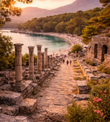
Why Phaselis Ruins and Beaches are worth it ✅
Phaselis isn’t just “ruins next to water.” It was a major ancient port city, enriched by maritime trade thanks to its three harbors, and it’s known for impressive Roman-era engineering (especially its water distribution and drainage systems).
What makes the day feel special:
- Ruins in a forested seaside setting (shade matters in summer) 🌲
- Swim breaks inside the same site (no extra driving between “culture” and “beach”) 🏊♂️
- A walkable layout with a memorable main axis and monuments tied to major historical periods
Quick orientation: the 3 harbors + beaches (choose your bay) 🗺️🏖️
Phaselis has three main harbors: North Harbor, Military Harbor, and South Harbor.
A key practical point: all three have beach access for swimming, and the South Harbor is typically a short walk deeper through the site.
Bay comparison table (fast decision) ✅
| Harbor / Beach | Best for | What it feels like |
|---|---|---|
| North Harbor | Quick dip + easy access | The “arrive and swim fast” option |
| Military Harbor | Calm swim + close to core ruins | Great balance of ruins + beach |
| South Harbor | More “escape” vibe | A bit more walking; feels more secluded |
(Port names and the “three-harbor” structure are documented by the Antalya Provincial Directorate of Culture & Tourism; the “all three have beaches” and South Harbor walk note are stated on GoTürkiye.)
The best Phaselis Ruins and Beaches route (2–4 hours) 🚶♂️📍
Phaselis is easy to wander randomly, but this route keeps the day smooth and makes the city’s structure “click.”
1) Start with the harbors: see the geography first 🌊
Before you get lost in stones, stand at a harbor viewpoint and understand why this was a port city. The entire site makes more sense once you see the bays.
2) Walk the main street (the signature “ancient boulevard”)
The official museum listing points out that the main remains line the main street connecting the Military Harbor and South Harbor, and it even gives measurements: the street is described as 20 meters wide with a 125-meter stretch, with sewage and drainage beneath the paving.
That’s not trivia—it’s why the walk feels unusually “city-like” instead of scattered ruins.
3) Look for the “Hadrian moment” (monumental arch context)
Both official summaries emphasize that Emperor Hadrian visited Phaselis (and a monumental element was connected to that memory).
Even if you don’t chase every inscription, it helps you understand Phaselis as a city important enough to host and commemorate imperial visits.
4) Add the essentials: theatre + agoras + baths
The museum listing notes Phaselis had a theatre and three agoras, and it describes two baths, including a smaller bath that can teach you about Roman heating systems.
Don’t “collect” these like a checklist—pause for 2 minutes at each and imagine daily life around the street.
5) Finish with your swim (or start with it) 🏊♀️
If it’s hot, do a swim first, ruins second, then swim again. If you want better photos and calmer walking, ruins first, then beach.
What to see inside the ruins (high-value highlights) 🏛️✅
Phaselis as an “engineering city” 💧
The official museum page emphasizes Phaselis’ Roman-period water system: water was brought from a northern source via aqueducts and distributed by channels/pipes, while the main street had integrated sewage/drainage.
If you want one theme to follow while walking, make it water: where it came from, how it moved, and how the city managed runoff.
The three-harbor urban logic ⚓
The three ports weren’t a tourist gimmick—they were the city’s advantage. The Antalya provincial cultural page lists the ports and places them geographically on the peninsula.
Pine forest + coastline = the “Phaselis mood” 🌲🌊
Phaselis is repeatedly described as sitting in the shade of rich pine forests near the shore—part of why it’s such a good half-day escape from central Antalya.
How to get there 🚗🚌
Phaselis is in Tekirova (Kemer), Antalya, and the official museum listing provides the site address as Tekirova Mahallesi 8011 Sokak No:1, Kemer / Antalya.
By bus (DIY-friendly) 🚌
The Culture Portal specifically notes you can reach Phaselis using Antalya → Kemer → Tekirova buses.
From Tekirova-area stops, you typically continue with a short taxi ride or local connection depending on where you get off.
By car / taxi 🚕
If you’re combining ruins + beach gear (towels, water, snacks), car/taxi is the simplest door-to-door option.
Hours / Operating times ⏱️
The official Phaselis listing currently shows:
- Opening: 08:00
- Closing: 17:00
- Ticket office closes: 16:30
- Open every day
✅ Practical planning rule: arrive by 14:00–15:00 if you want ruins + swim without rushing.
Tickets / prices / MüzeKart 💳
For pricing, use the Ministry’s official fee list:
- Antalya Phaselis Örenyeri: €10
The official e-ticket flow also lists Phaselis e-ticket as 10 Euro.
For Turkish citizens:
- The Phaselis site listing states MüzeKart is valid for Turkish citizens.
⚠️ Because Phaselis sits within Beydağları Sahil Milli Parkı, you may also encounter park-related rules depending on access/vehicle entry; follow posted signage and official guidance.
Tips & common mistakes ✅⚠️
Do this ✅
- Bring water shoes or sturdy sandals (pebbly entry can be uncomfortable).
- Pack a small dry bag for phone/keys if you plan multiple swims.
- Use a two-scan strategy: (1) fast loop for orientation, (2) slow loop for photos and details. 📸
- Plan shade breaks in the pine areas (this is one reason Phaselis is so pleasant).
Avoid this ⚠️
- Doing only the “first bay” and leaving—you’ll miss why it’s a three-harbor city.
- Arriving late and expecting a full ruins walk + beach (ticket office stops at 16:30).
- Treating it like a “museum-style” visit—this is a mixed day: ruins + sun + saltwater. Plan accordingly. 🧢💧
FAQ (Phaselis Ruins and Beaches) ❓
Is Phaselis Ruins and Beaches good for a half-day trip?
Yes—Phaselis is built for a 3–5 hour plan (ruins loop + swim). The site layout and beach access make it ideal.
How many harbors does Phaselis have?
Three: North Harbor, Military Harbor, and South Harbor.
Can you swim at Phaselis?
Yes—GoTürkiye notes all three ports have beaches you can swim from.
What are the official opening hours?
08:00–17:00, ticket office closes 16:30, open daily (official listing).
How much is the ticket?
The official fee list shows €10 for Phaselis Örenyeri.
Is Phaselis inside a national park?
Yes—official national park info identifies Phaselis (Tekirova) as a key historical settlement within Beydağları Sahil Milli Parkı.
Conclusion
Phaselis Ruins and Beaches is one of the best “one-stop” days near Antalya: an ancient port city with a readable Roman street plan and water engineering—plus multiple swimmable bays inside the same peninsula setting. ✅🌊
Go early, walk the main street slowly, choose your harbor intentionally, and treat the day as a ruins-and-swim loop—not two separate trips.
Comments