
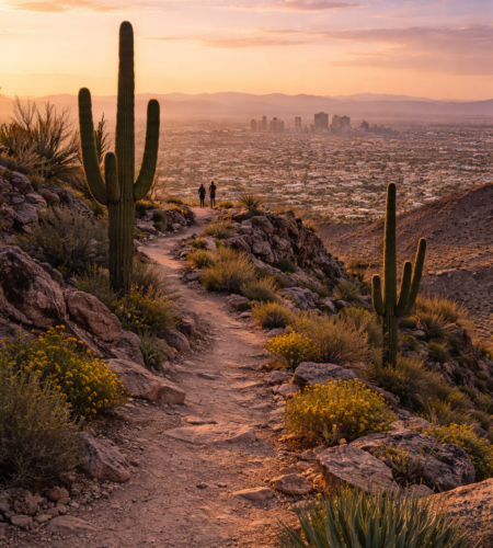
South Mountain Park & Preserve is Phoenix’s “big wilderness in the city” moment: a massive desert preserve with multiple trailheads, panoramic viewpoints, and a scenic summit road—close enough for a quick sunrise hike, but big enough to feel like you’ve left town. The City of Phoenix describes it as more than 16,000 acres with 100+ miles of trails, spread across three mountain ranges.
This guide is designed for real planning: which trailhead to use, what’s actually worth your time, the official hours, how Silent Sunday works, how to avoid heat mistakes, where you’re likely to find petroglyphs—and the quickest “no-regrets” itineraries.
Why South Mountain Park & Preserve is worth it 🌵✅
A lot of Phoenix hikes are “one peak, one trail.” South Mountain Park & Preserve is different: it’s a whole network—easy desert strolls, moderate climbs, long ridge routes, bike-friendly options, and paved road access to viewpoints.
Key reasons it’s a top pick:
- Scale: over 16,000 acres and 100+ miles of trails (City of Phoenix).
- Views without a huge climb: Dobbins Lookout (2,330 ft) is the highest publicly accessible point in the park and can be reached by road or trail.
- History + culture: South Mountain is home to thousands of Hohokam petroglyphs, and the city provides guidance on how to view them without damaging them.
South Mountain Park & Preserve hours (and the gate “gotcha”) ⏱️⚠️
This matters because the trails stay open later than the gated entrances.
- Parking/Entrance hours: 5 a.m. – 7 p.m.
- Trail hours: 5 a.m. – 11 p.m.
- South Mountain Visitor Center: Thu–Sun 9 a.m. – 3 p.m.
Practical takeaway: if you’re driving, plan to be inside the gates well before 7 p.m.; if you arrive at 6:55 p.m. expecting a sunset stroll, you’re gambling with access.
Best viewpoints in South Mountain Park & Preserve 📍🌄
Dobbins Lookout (the classic)
- Elevation: 2,330 ft (highest public point in the park).
- Why go: huge valley panorama + stone ramada shade at the top (great for sunrise/sunset).
Drive option: Summit Road is the main scenic roadway up (and it’s shared by cars, cyclists, hikers—so take it slow).
Buena Vista / ridgeline views (for hikers)
Many routes connect to the National Trail ridgeline, where you get big open views without needing to be at Dobbins. Trails like Holbert, Mormon, Pyramid, and others can connect you up there.
The best hikes in South Mountain Park & Preserve (choose your difficulty) 🥾
Here’s a practical “pick one” table using the City of Phoenix trail descriptions.
| Route | Start (trailhead) | Distance / elevation (official) | Difficulty | Best for |
|---|---|---|---|---|
| Holbert Trail → Dobbins Lookout | Holbert Trailhead (main entrance area) | 2.5 mi; +1,100 ft | Moderate/Difficult | Classic climb to the big view |
| Mormon Trail → National Trail → Hidden Valley | Mormon Trailhead | Mormon Trail 1.1 mi; +720 ft; Hidden Valley Trail 0.5 mi | Moderate/Difficult | Iconic loop with rock features + “Hidden Valley” vibe |
| Kiwanis Trail (connector-style hike) | Kiwanis Trailhead (near main entrance area) | 1.0 mi; +480 ft | Moderate | Shorter hike that still feels like “real desert” |
| Desert Classic Trail (long, easier-grade option) | Pima Canyon Trailhead | 9.0 mi; +270 ft | (City listing shows as a standard trail) | Longer walk/run/bike-friendly route with less climbing |
Reality check: distances above are the official per-trail numbers; your actual out-and-back/loop distance depends on how you connect trails.
Silent Sunday: the best time for cycling, walking, and “no cars” roads 🚲✅
Silent Sunday is one of the most underrated features of South Mountain Park & Preserve—because the main roadway becomes a people-first route.
- 4th Sunday of every month: Summit Road closed to public motor vehicles all day (5 a.m. – 7 p.m.).
- Other Sundays (1st, 2nd, 3rd, 5th): shortened closure 5 a.m. – 10 a.m., with the summit road closed at the 1.0 mile marker.
Pro tip: If your goal is Dobbins Lookout by car, don’t show up on the 4th Sunday expecting to drive up—plan to hike, bike, or pick another day.
Hohokam petroglyphs: what they are and how to see them without damage 🪨⚠️
The City of Phoenix notes South Mountain is home to thousands of petroglyphs, primarily attributed to the Hohokam culture, with the Hohokam timeline commonly cited as roughly AD 450–1450.
Important etiquette (and it’s not optional):
- Don’t touch rock art—oils from hands can damage it.
- Stay on the trail to protect habitat and the sites.
- Rock art is noted along trails including Judith Tunnell Accessible Trail, Telegraph Pass, Kiwanis, Mormon Loop, Desert Classic, Mormon Trail, Holbert, etc.
Heat rules in South Mountain Park & Preserve (this can change your plan) ☀️🚨
Phoenix has a formal heat safety program. On days when the National Weather Service issues an Extreme Heat Warning, the city restricts certain South Mountain access from 8 a.m. to 5 p.m.—but it’s not the entire park.
The city’s heat safety page lists restrictions including:
- Holbert Trail
- Mormon Trail
- Hau’pal Loop Trail
- Access to the National Trail from the Pima Canyon Trailhead
They also emphasize that most of the park remains accessible during these warning-day restrictions (the city describes fewer than ~7 miles impacted in that specific program update).
What this means for you: if you’re visiting in summer, plan sunrise/early morning. If an Extreme Heat Warning hits, pivot to cooler trails that remain open or switch to indoor Phoenix plans (museums, etc.).
How to get to South Mountain Park & Preserve 🚗🚕🚌🚊
By car (most common)
South Mountain has multiple access points. Commonly listed trailheads/entrances include:
- Park Main Entrance (Central Ave)
- 19th Ave Trailhead
- Mormon Trailhead
- Beverly Canyon Trailhead
- Pima Canyon Trailhead
- Telegraph Pass Trailhead
By rideshare
For first-timers, rideshare works best if you set the destination as a specific trailhead (Mormon / Pima Canyon / Main Entrance), not “South Mountain” broadly.
By public transit (doable, but plan it)
South Mountain is huge, and transit access depends on which trailhead you want. Valley Metro recommends using its Trip Planner and route maps to build the best bus/light rail combo for your start point.
Useful note for Phoenix visitors: the South Central Extension/Downtown Hub opened June 7, 2025 and extends light rail south along Central/1st avenues toward Baseline Road—helpful for reaching South Phoenix corridors and then connecting via bus/rideshare.
Tickets / prices / permits 💳
South Mountain isn’t a “buy a timed entry ticket” destination like a zoo or museum. Most visitors are planning around parking access, trail choice, and heat rules.
That said, there are paid elements:
- Ramada reservations / special activity permits may be required for certain reserved structures and organized activities (the city uses a special activity request process).
- Special events exist (example: National Trail Trek is a paid event with a listed cost).
Quick cost table
| Item | Typical situation |
|---|---|
| Day visit (hike/drive viewpoints) | Usually no “ticketing” step—plan for rules/hours instead |
| Reserved ramada / organized activity | Permit process may apply |
| Special events | Can be paid (example: National Trail Trek lists a fee) |
Tips and common mistakes (South Mountain Park & Preserve edition) ✅⚠️
- Arriving after 7 p.m. and expecting to park at the main gate. Trail hours go later, but gated parking/entrance hours are earlier.
- Driving Summit Road like it’s a normal city street. The city warns about blind corners, narrow sections, and drop-offs—take it seriously.
- Planning Holbert/Mormon on an Extreme Heat Warning day. Those are specifically called out in the heat safety restrictions.
- Touching petroglyphs or going off-trail for photos. Don’t—take photos from the trail and leave everything as-is.
- Showing up on the 4th Sunday expecting to drive up Summit Road. Silent Sunday changes vehicle access.
FAQ (South Mountain Park & Preserve)
What are South Mountain Park & Preserve hours?
Parking/entrance hours are 5 a.m.–7 p.m.; trail hours are 5 a.m.–11 p.m.
What’s the best viewpoint?
Dobbins Lookout is the highest point in the park available to the public (2,330 ft), reachable by road or trail.
What is Silent Sunday?
It’s when Summit Road is closed to motor vehicles (all day on the 4th Sunday; mornings on other Sundays).
Where can I see petroglyphs?
The city notes thousands of petroglyphs exist in the park and lists multiple trails where rock art can be found; stay on trails and don’t touch.
Do trails close for heat?
On Extreme Heat Warning days, the city restricts specific South Mountain trails and access points from 8 a.m.–5 p.m.
Conclusion
South Mountain Park & Preserve is the most versatile outdoor stop in Phoenix: you can do a short family-friendly stroll, a serious ridgeline hike, a scenic drive to Dobbins Lookout, or a car-free road workout on Silent Sunday. Plan around the official gate hours, treat heat warnings as real constraints (not suggestions), and you’ll get the “Sonoran Desert + skyline” experience with way fewer headaches.
Comments